Monday, October 24, 2011

Candidates 2011

Below are the Traverse City Commission and Mayoral Candidates for 2011.

I don't know who I am voting for yet. I know who I won't be voting for but that still leaves some vacancies. At this point I'll vote for whoever is the most reasonable person.

To help organize my voting decision I've linked to the candidate profiles in the Record-Eagle, their answers to the MyWheelsAreTurning.com survey, the 2011 Candidate Forum answers at the TC Chamber, and a meta search which will search for the candidate's name at local web sites (TCLP, City of TC, MWaT, PlanForTC, MLUI, GT County, UpNorthLive, TheTicker, TC Biz News, Record-Eagle).

*note that PDF's from the City of Traverse City are generally image files rather than text files and therefore are not searchable, which is a pain

At the bottom you can use my custom domain search if you'd like to search the above domains for your own queries. For more political insight you can also use the Fundrace tool which allows you to search political contributions by name and address.

Budros: TC Chamber forum responses / Record-Eagle profile / MWaT answers / meta-search

Carruthers: TC Chamber forum responses / Record-Eagle profile / MWaT answers / meta-search

Donick: TC Chamber forum responses / Record-Eagle profile / MWaT answers / meta-search

Easterday: TC Chamber forum responses / Record-Eagle profile / MWaT answers / meta-search

Ford: TC Chamber forum responses / Record-Eagle profile / MWaT answers / meta-search

McGuire: TC Chamber forum responses / Record-Eagle profile / MWaT answers / meta-search

Werner: TC Chamber forum responses / Record-Eagle profile / MWaT answers / meta-search

Estes: TC Chamber forum responses / Record-Eagle profile / MWaT answers / meta-search

Soffredine: TC Chamber forum responses / Record-Eagle profile / MWaT answers / meta-search

Search Traverse City news and government web sites:
Loading

Missing Links For 10-24-2011

(some things I have been reading but not posting)

AtlanticCities: The Economics of Urban Trees

Steamboat Springs is now branding itself as Bike Town USA
Steamboat Pilot: Steamboat's plans for biking could offer business opportunities

DenverPost: Steamboat Springs vying for top cycling destination
Steamboat is primed to be a vibrant bike destination. Two boutique bike makers, Moots and Eriksen, are crafting high-end rides in town. Honey Stinger, the nation's largest maker of honey-based energy food and co-owned by Lance Armstrong​, is based in Steamboat. Point6 socks and SmartWool apparel are headquartered in Steamboat and are popular with cyclists...

...Painted bike lanes and sharrows adorn most city streets. New directional and "Share Our Road" signage will be in place soon. On the backside of Steamboat's Howelsen Hill​ ski area, new volunteer-built singletrack on BLM land is harvesting accolades. The Beall Trail opened in July with a wildly successful 50-mile mountain bike race, one of the city's 40 cycling events every summer.

VanityFair has some Leelana County pics from Batali: Chef Mario Batali’s Delicioso Stash of Food Camera-Phone Photos

PhysOrg: New research finds that homeowners and city planners should 'hit the trail'
housing prices went up by nine dollars for every foot closer to the trail entrance. Ultimately, the study concluded that for the average home, homeowners were willing to pay a $9,000 premium to be located one thousand feet closer to the trail.

PhysOrg: Dam removal increases property values

TheAtlanticCities: As America Ages, NIMBYism Could Increase
The report finds that people aged 56-65 are most likely to actively oppose new projects in their communities, while people aged 21-35 are most likely to actively support projects.

-> related from TheTicker: The Big Boom: Senior Population Surging Up North

ECFRPC: Economic Impact of Trails in Orange County [these trails total about 35 miles; for comparison TART's Leelanau + TART + Boardman Trails are about 28 miles]
It was determined that in 2010 in Orange County, theses trails supported 516 jobs and an estimated economic impact of $42.6 million.

CR: BlackBerry service failure cuts Abu Dhabi crashes by 40 percent

Friday, September 30, 2011

Historical Perspective

Some new tools are online that let you see how an area used to look.

The USGS has made available 125 years of Historical Topographic Maps

So much wilderness east of town in the 1950's

Another site is WhatWasThere.com
This site lets you overlay historical photographs over Google Street view.

Here's the
Park Place Hotel.


Found some other sites that show how cities have traded density for parking lots. So I took their photographs and made animated gif's out of them (sorry, at least the animated gifs aren't from an old geocities site).

The Atlantic on how parking lots ruined Cleveland's warehouse district: Cleveland's Disappearing Warehouse District, Then and Now


Thoughts on the Urban Environment has a similar example from St. Paul: The last 47 years have not been kind to 7 Corners


These images remind me of an online tool from MIT Media Lab called Place Pulse.

What they do is present two similar images from cities and present the question "Which place looks safer, more unique, or more middle class?" You're asked to click on your choice as quickly as possible. This gets repeated hundreds of thousands of times with people from all over the world and the results are grouped into what humanity as a whole regards as safe, unique, or middle class.

You can view the results without going through the process.

What is clear is the human brain perceives urban density as safer than parking lots.

Missing Links

For the end of September; some things I find pertinent but don't have time to write about.

-TCArtichoke: TC's Right Brain Brewery Automates with New Serving Options [satire]

This is a response to personnel changes at RBB that were not handled very well on Right Brain Brewery's Facebook page so they just deleted a bunch of comments.

-Kind of related and also on Facebook, Brewery Terra Firma says they'll be open in the first quarter of 2012

-Crain's Detroit: Cherry Republic’s ‘ambassador’ has ambitions that involve more than just fruit
“Does the city stay 100 years ago, and all the buildings look like they did 100 years ago, or is there room for some newness in a city?” Sutherland said. “We believe there is room for an iconic building for cherries for Traverse City that is inspiring, that says good things are happening downtown.”

Well, thanks, but no, thanks, says one local city official: Jim Carruthers, a member of the Traverse City Commission and an outspoken critic of the project.

-Crain's Detroit: The pitfalls of being the Cherry Capital — why northern Michigan should diversify its diet

-Slate: Lunch With Michael Moore: He hugs Republicans almost every day
Moore comes to the city to work, most recently on a memoir, and "to get some privacy". He is a public figure in Traverse City, his home on Lake Michigan, not just for his Oscar and Palme d'Or wins but for starting a film festival in 2005 that has given its economy a much-needed boost. He relishes the irony of the Republican-dominated local business association naming him businessman of the year, an unexpected accolade for the man behind leftwing film, television and print polemics including Capitalism: A Love Story (2009), a post-crash indictment of big business.

-Sad stats: 30.5% of Michiganders are obese; 1.2% more than last year. In 1999 not a single state was over 15%. See TheAtlantic: The 10 Fattest States in America

-AtlanticCities: Debunking the Cul-de-Sac
the safest cities had an element in common: They were all incorporated before 1930. Something about the way they were designed made them safer. The key wasn’t necessarily that large numbers of bikers produced safer cities, but that the design elements of cities that encouraged people to bike in places like Davis were the same ones that were yielding fewer traffic fatalities.

These cities were built the old way: along those monotonous grids.

-For a an economic and geological explanation of peak oil see The Oil Drum: A Brief Economic Explanation of Peak Oil

-Green Car Congress: Study shows that urban cyclists have higher levels of black carbon in lungs than pedestrians

Wednesday, September 14, 2011

Well Done Jackson, WY

Traverse City had the "Your Bay, Your Say" sessions in 2005 and we're still waiting for implementation of a bayfront park.

The Teton Boulder Park was conceived in 2009 and opened before the end of 2010.


[Via Adventure Journal: Teton Boulder Project Comes to Life in the Heart of Jackson Hole]

Love it. A great idea and a great looking park and it went from idea to implementation quickly because the City and Businesses all got behind it.

Another reminder of how slow things are here in Traverse City is the Hotel Indigo. News of a hotel in the warehouse district came in 2008, today's update at MWaT: The Hotel Indigo Tunnel Returns indicates the hotel may not happen at all.

Monday, September 12, 2011

Community Conflicts

Today's Ticker: TCFF & Paella: Summer 2012 Woes hit on something I was thinking about this past weekend.

No, not "these pirates are not historically accurate representations of pirating in the Great Lakes" nor was it "I have to pay for a Pirate breakfast and coffee is $1.75 extra?!" but rather "how many festivals are there?"

This past weekend we had the Michigan Schooner Festival, the Epicurean Classic, the NMC Mike McIntosh Memorial Truck & Car Show, and Acme Fall Fest. I'm sure I am missing some things.

The most people I saw at the Schooner Festival were the throngs outside of the paid area to watch the ships under sail Friday night. The Epicurean Classic was using tents on Garland St. - less dignified surroundings than in previous years and I heard turnout was less too.

In August The Commons has a Wine and Art Festival one weekend and a Microbrew and Music festival the next. Wuerfel Park had a beer festival this year too.

So many festivals, so little time. Could any of these be combined or scheduled more efficiently?

For example, if the Classic Boats on the Boardwalk and the Schooner Festival were the same weekend wouldn't their combined draw be more than each on its own?

Who could be a liaison between all of these festivals?

Mayor Bzdok wants a Neighborhood Ombudsman.

I've been against the City adding a neighborhood advocate because:

1.) isn't this why we elect City Commissioners?

2.) we need to think of ourselves as a single City rather than a series of tribes or neighborhoods.

3.) neighborhoods tend to advocate for their own interests rather than the City's best interest.

Examples include Slabtown neighborhood wanting their own beach even though there is a nearby existing beach and research shows beach grooming degrades fish habitat directly offshore and up to 150 ft along the shore.

Central neighborhood wants to keep Seventh and Eighth streets one way even though it can be easily demonstrated that two-way streets are better for the neighborhood and city.

Old Town Neighborhood Association wants a bypass built next to Boardman Lake even though a comprehensive 10 year traffic study from the University of Toronto clearly shows more roads always lead to more traffic.

Three neighborhoods wanting what they think is best for them but when taking the big view could actually lower the quality of life in the City.

I am not sure someone advocating for the neighborhoods would help.

Something that might help is this question a friend posed: why don't we elect City Commissioners by district like at the County? I like it, each neighborhood could elect their own commissioner and then each neighborhood would have their own official advocate.

Then could the Neighborhood Ombudsman idea be expanded into a Community Ombudsman? Someone who could coordinate events and resolve conflicts with all of these festivals and non-profits and also serve as a single point of contact for citizens' concerns and complaints.

Just a thought I had this weekend.

Venice Calling

The Traverse City Commission will consider the Bayfront Plan tonight and what to do about the Spirit Of Traverse City.

I will be telling them I support moving forward with redeveloping Clinch Park without the train even though I have a child who cried when told this might be the last year for the train. (She stopped crying when told there could be a splash park instead and she said that sounded more fun and wouldn't be smelly).

Nostalgia can wound a city.

Venice, Italy was once the center of an ocean-going empire and a key city-state during the Renaissance. But today it has become obsessed with nostalgia and the residents who remain do not let it change. In response the city is literally fading away. It is drowning under a rising ocean and losing population because no one there actually does anything. Or as The Guardian said in 2006: Population decline set to turn Venice into Italy's Disneyland

For comparison, in 1929 New York City tore down the historic Waldorf Astoria hotel to build the Empire State building. A new Waldorf Astoria was built and the Empire State Building became the city's iconic structure.

Let's be less like Venice and more like New York. I want Traverse City to be more than an amusement park in city form that people come to visit. I want it to be a city full of people who do things.

The new Bayfront Park will likely bring more stature to TC than the Spirit of Traverse City has. It is a design that encourages people to do things. This doesn't mean the train cannot be kept and moved elsewhere, but a train at Clinch Park is incompatible with the vision that was developed.

On a final note, please don't take this to mean that in every case we should move out with the old in with the new. Like everything else, a city needs to find a balance between what it keeps and what it replaces with something better. Like how I choose to live in a 19th Century house full of 21st Century technology.

Friday, September 9, 2011

Safety And Liability

Safety isn't a political issue. I have family in the reddest part of the reddest state.. They live in a county the size of Connecticut without any traffic stop lights. They do have signs and laws that traffic has to yield to pedestrians, and this is on US Hwy 191. Still, when I was there this summer they were installing new pedestrian crossing lights.

See PinedaleOnline: Pedestrian ‘Hybrid’ beacons to be installed in Pinedale

I'm all for Traverse City requiring traffic to yield to pedestrians.

Wonder if this will mean that the Spirit Of Traverse City will have to yield to pedestrians too?

Today The Ticker reported on the little train's unsettled fate: Will TC Blow the Whistle on the Train (Again)?

My kids love riding the train. But if they were on it and it derailed again I'd be tempted to sue the City for negligence. Because it has happened before. See the Record-Eagle: No injuries after mini train derails


This summer a teenager was tragically electrocuted and drowned in the marina. The City is going to get sued for negligence. See IPR: Lawsuit Expected Next Week in TC Marina Drowning

Because back in June there was this posting at ThirdCoastSurfShop.com: Take Caution which warned other paddlers that there were electrical problems in the Traverse City marina.

I see parallels between these events. Known dangerous circumstances on City property. Luckily no one has been injured on The Spirit yet but if the derailment cause was never determined then it could happen again. It isn't hard to envision the next derailment injuring a small child.

Though perhaps the nostalgia is worth it? I don't know the answer.

Just as I don't have the answers to the technical questions that need answered today and years from now too:

-Who fixes the train when it breaks down?
-Are spare parts available?
-Will technicians be available to maintain it?
-Will fuel be too expensive some day?
-Who will push the train up the final stretch when it gets bogged down?

And I have to think the City's insurance to cover the train will probably go way up after the marina lawsuit. The City may be forced to give it up due to liability worries. That's one way to settle a debate.

Bending The Culture Curve

There's been a lot of news since the last post about complete streets and safety at this site.

Traverse City leaders are making traffic safety a priority and released a Bicycle Safety Rules PDF.

Also See IPR: Bike-Car Crashes Concern City Leaders In T.C.

There was a study released on the most dangerous cities for pedestrians in the U.S.
See NYT: On Wide Florida Roads, Running for Dear Life

And the University of Michigan did a study that concluded Michigan traffic accidents have a higher external cost to society than crime.
See DetNews: Traffic crashes cost Michigan $9.1B, more than crime

These reports gave me the impetus to mention something that I neglected in The Mandate Of Complete Streets.

That is Culture. What makes walking part of a culture and why are some areas safer? Is there a culture of safety?

When I think of a walking culture I think of the U.K. Specifically, The Ramblers. Walking is so important to the fabric of English society that the Ramblers ensure that at least once per year every foot path in the U.K. is traveled in order to maintain the public's right-of-way.

Can we have that? How do we make walking safely part of our culture when for the last 50 years the United States has been expanding roadways and making roads safer for vehicles but dangerous by design (Transportation for America PDF report) for everything else? How does the culture buy into the idea that more than vehicles move?

While Complete Streets are a new thing in the U.S., the similar concept of Living Streets has been in England since 1929.

So we could wait 80 years and let the ideas of Complete Streets filter through the culture, or we could use data to drive our decisions.

At my job I analyze data sourced from across Michigan and establish baselines of how many Internet problems per number of devices is normal and then look for areas with abnormal trouble rates and search for ways to lower that baseline rate.

When I read the University of Michigan Transportation Research Institute study: Societal costs of traffic crashes and crime in Michigan: 2011 update, I realized similar data was available in the study's data source: 2009 Transportation Data Center
Data Set Codebook


We had accidents per county and the census can give us population. Perhaps I could apply them?

I found some Michigan web sites with traffic crash data:
-Michigan Traffic Crash Facts
-Michigan State Police Traffic Crash Statistics
-Michigan State Police Traffic Crash Reporting Information

They had the reports I was looking for as PDF's:

-2010 Michigan Traffic Crash Facts for County/Communities
-MICHIGAN STATE POLICE CRIMINAL JUSTICE INFORMATION CENTER CRASH STATISTICS NUMBER OF CRASHES REPORT STATEWIDE TOTALS FOR 01/01/2010 THROUGH 12/31/2010 (all caps is the original format)

Methods

I used the 2010 Census to get population numbers.

I exported the crash data from the PDF's to a spreadsheet.

I then calculated median accident rates per number of people in the community and also plotted these on a graph to look for trends.

I did not expect to see any trends or correlations as there seemed to be so many different variables that can have an effect on traffic accidents. But that is not what I found.

Results

The calculated median accident rate for Michigan in 2010 is 32.2 accidents per 1000 people. And it all fit on a trend line (which surprised me):


Next I uploaded the tables to OpenHeatMap to see if there was any pattern to which counties were above this 32.2 accident rate and which were safer. Green is a lower accident rate and red is a higher accident rate by population.

Link to larger version: Michigan County Accident Rate (You can hover over each county to see its Accident Rate score)


It appears to me that rural counties have a higher rate of accidents when weighted for population.

I then applied the same methods to Bicycle Accidents and Pedestrian Accidents.

The calculated median bicycle accident rate for Michigan in 2010 is 0.13 accidents per 1000 people.


Full size Map: 2010 Michigan Bicycle Accident Rate


The calculated median pedestrian accident rate for Michigan in 2010 is 0.15 accidents per 1000 people.


Full size Map: 2010 Michigan Pedestrian Accident Rate


The Bicycle and Pedestrian Accident rates do not show as strong a correlation as total accidents but there is still a pattern.

When looking at the county maps it appears to me that the counties with a strong biking culture have the highest rate of bicycle accidents. These would be counties hosting large Universities where many students use bikes out of necessity and Grand Traverse County where people choose to ride.

It is harder to make sense of the Pedestrian Accidents map. It could be suburban walkers who don't have access to sidewalks are in greater danger.

To explore this possibility I made a map of the Walk Scores Of Michigan's 65 Most Populous Cities with data from WalkScore:


What you see is that city cores have higher walk scores and the suburbs get progressively worse (clearly evident in Wayne County). But is this related to safety?

At MichiganTrafficCrashFacts.org there is a Data Query Tool that lets you build specific maps and tables for defined areas. I used it to look at Traverse City and Grand Traverse County.

2010 Crashes in Grand Traverse County involving pedestrians:


You can see that though many pedestrian accidents were reported within Traverse City proper these usually did not result in injury. But the pedestrian accidents in Grawn, Kingsley, and Williamsburg while fewer in number resulted in serious injury and fatalities.

2010 Crashes in Grand Traverse County involving bicycles:


What I see on this map is more bike accidents downtown, but worse injuries outside of downtown.

What do we do?

Based on these maps and tables I believe that implementing design concepts such as Complete Streets can make roads safer for people, whether they are walking, riding a bike, or driving a car. And I believe that if we make the roads safer for all forms of transportation then more people start using those other forms of transportation. The economy, freed from the burden of unnecessary accidents, grows.

By bending the accident trend lines we can change the arc of our culture.

There are still many questions though and I hope that the research here can serve as a baseline for the future. Two big questions I look forward to having answered are:

-do communities that implement Complete Street designs see their Accident Rate decline?
-do communities with better WalkScores have lower accident rates?

For anyone who wants to do their own research I have uploaded my spreadsheet to Google Docs from there is it easily exportable.

Thursday, September 8, 2011

How Sleeping Bear Dunes Was Liked

Sure, we all like the national lakeshore but the most beautiful place in America? As Carl Sagan said, "extraordinary claims require extraordinary evidence".

The evidence is that Good Morning America saw 22,000 votes for Sleeping Bear due to the mobilization of social media in northern Michigan.

See Crain's Detroit: The sleeping giant behind Sleeping Bear: How scenery and social media created ‘The Most Beautiful Place in America'
This time of year, the Sleeping Bear website typically gets about 1,500 to 2,000 hits a day. On Aug. 17, when the “Most Beautiful Place” selection was made, the site got nearly 15,000 hits.

Monday, August 15, 2011

The Mandate Of Complete Streets

(Today's post at MWaT: Are Our Driving Skills A Collective Effort? reminded me to finish this post that I started earlier this summer)

When I think of Complete Streets I think of streets that are safe for everyone. And by making streets safer we lower what economists term externalities or "social costs".

A street designed as complete will be safer for everyone resulting in a net economic gain to society.

In other words, what is a life worth? Not just to that person's family and friends but to the economy as a whole? What are the economic benefits if lawsuits are kept out of the courts, insurance isn't used, employees don't miss work, first responders are available for other emergencies, and on and on?

Traverse City has had numerous conflicts this year between street users.

Example from 9and10: Two Bike, Car Crashes In One Week, Police Cautioning Everyone Be Safe

These pedestrian-bike-vehicle conflicts are happening across the country just as they did in 2008 when there was a spike in gasoline prices forcing people out of their cars.

The most well known accident this summer is the case of Raquel Nelson whose 4 yr old son was struck and killed while attempting to cross a multi-lane road (See NPR: Child's Death Casts Light On Pedestrian Traffic Woes)

A similar tragedy occurred in Traverse City in 2007. See the Record-Eagle:Boy from Greece, 6, killed in accident on U.S. 31
The boy's family stopped in the turn lane halfway across the road to wait for traffic to clear...

As a parent it is hard to imagine anything more horrific than having my child being run over by a semi-trailer while I helplessly watch and knowing design choices played a part in the tragedy.

Doesn't seem appropriate to call these accidents as if they were unpreventable.

Plenty of studies indicate the dangers poor street design poses. See Wired: Report: Streets Pose Mortal Threat to Pedestrians
More than 47,000 people were killed walking the streets of the United States between 2000 and 2009


And while dedicated bike lanes can improve safety for bicyclists pedestrians are always the most susceptible street users as a recent bike-pedestrian accident in San Francisco demonstrates (via NPR).

In the case of Raquel Nelson she was facing three years in jail for jaywalking, the person who was in the car that killed her son? Two years of jail time.

And here we have the problem. It seems that in a state where we are free to walk the beaches of the Great Lakes we are not welcome to walk across the street.

What Grist calls the criminalization of walking.

This is a design decision. Driving requires concentration though we act like it does not. It is why I won't even talk to my passengers when I drive. Yet I still feel the same urges to speed or to use my vehicle to "teach a lesson". We all drive on the road given to us. Apply the neuroscience of behavioral economics to roads and design streets for people.

That is my three word description of Complete Streets: design for people.

This is my hope for Complete Streets in Michigan. A stronger economy by design. And not just in the reduction of negative externalities, but as Fast Company reports complete streets build jobs: Want Jobs? Build Bike Lanes
Cycling projects create a total of 11.4 local jobs for each $1 million spent. Pedestrian-only projects create a little less employment, with an average of 10 jobs for the same amount of money. Multi-use trails create 9.6 jobs per $1 million--but road-only projects generate just 7.8 jobs per $1 million.

Thursday, August 11, 2011

More About The Garfield Township Parks

The Ticker today covered the hidden parkland in Garfield Township. See: Garfield's Secret Green

Intrigued, I visited the Garfield Township Parks & Rec web site and found they have a Google Map of their parks:


View Garfield Township Parks in a larger map

and they have a PDF you can download of all parkland "including Grand Traverse County Parks, City of Traverse City Parks, and Grand Traverse Regional Land Conservancy Parks."


Very nice!

Friday, July 8, 2011

Colorado River's Big Sur

Is a standing wave that only occurs when the flow rate gets above 20,000 cfs.

It has been at about 30,000 cfs recently.

DenverPost reports: Once-in-a-generation wave continues in Debeque Canyon
With waves surging to nearly head high, strong surfers can ride the never-ending wave nonstop for more than an hour on uncrowded days.

[via AdventureJournal]

The article mentions a person who has made the 4-hour round-trip from Vail four times this month.

Message boards indicate people from Utah and Montana are making the trip to experience this wave. Even a person in Connecticut is going west to surf in the Colorado River.

This kind of dedication is why a whitewater park in downtown Traverse City seems like a great idea.

Batali Is Checking In

In an interview for Family Circle Magazine Mario Batali had this:
Favorite getaways: "We have a quiet vacation home in Michigan. I'll spend two months there over the summer without a cell phone or computer, golfing, swimming in the lake, and cooking for family and friends. It's heaven!

If you follow Chef Batali on twitter you'll see he's tweeting and checking-in to foursquare from Leelanau county on his iPhone, so the part about spending the summer without a cell phone or computer may not be quite accurate. Though an iPhone is so much more than a cell phone so technically he is correct, but who cares? - I'm just happy to see how he's spending his time in our part of Michigan.

Friday, July 1, 2011

The Sara Hardy Downtown Farmer's Market Is Moving For Cherry Festival

Just as it always does, but this year to the Old Town Parking Deck.

A move I am quite excited to see as I have told people in the past that I think the parking decks can be used for functions other than parking.

My hypothesis is it'll be a great location for the Farmer's Market as there is built-in parking, coverage for people to get out of the elements, and it is still close to downtown. Other cities use their parking decks for the Farmer's Market so I am interested in seeing how this experiment turns out.

See you Saturday morning!

Monday, June 27, 2011

A Great Lakes Experience

Is Unsalted - A documentary on surfing the Great Lakes.


There are people who don't mind driving eight hours for maybe three hours of potential surfing.

Via Adventure Journal: More Core than Core: Surfing the Great Lakes

But a whitewater park provides steady conditions year-round and can be designed to accommodate surfers.

A whitewater park would give Traverse City another destination experience.

Friday, June 24, 2011

Your Speed

Is based on a feedback loop.

And you can be made to decrease your speed by 10% without even realizing it.

This is why a 'Your Speed' radar display is going up on W Front St.

Wonder how this works?

See Wired: Harnessing the Power of Feedback Loops

If you like this kind of thing then pick up a copy of the book Nudge.

1000 To 50

1000 commercial fishing licenses in Michigan to 50 today according to the Environment Report series Swimming Upstream which is investigating why it is so hard to find Great Lakes fish at your local market or restaurant.

GreatLakesWhitefish.com has more on Petersen Fisheries which is featured in the IPR story.

The next episode is about selling fish at the local Farmer's Market and how successful that has been for The Fish Monger's Wife.

So the next steps seems obvious, a CSF.

Community Supported Fisheries act like a CSA and allow you to get your fish directly, without a middleman. It means jobs for commercial fishers and fresh fish for consumers.

The most recent CSF I have read about is Off The Hook CSF in Halifax.

Wednesday, June 22, 2011

From Omaha to Old Town

After college a friend of mine moved to Omaha for a job in train logistics. That made sense to me. Rail yards and cows are what came to mind when I thought of Omaha. But that was as shortsighted as only thinking cherries when talking about Traverse City.

NPR and Wired have both recently covered the rise of Omaha.

NPR details how an arts destination can anchor professionals to the downtown: The Indie-Rock Club Behind Omaha's $100 Million Creative Boom

This sounds a lot like the plans for Old Town between Blue Tractor and the new Good Works Collective (See Northern Express: Room for a thousand and TheTicker:
New Performance Venue Coming to Old Town TC)

Wired details the phases of Omaha becoming a cultural mecca - focusing on food then arts then youth then parents: Case Study: Omaha, Nebraska (h/t glhjr)

If Omaha can do it we can too.

Thursday, June 2, 2011

What I Have Been Saying

It is pretty clear, via FastCompany: Building More Roads Only Causes More Traffic
a study from the University of Toronto confirms it: Expanding highways and roads increases congestion by creating more demand

And in a related piece, in the 1960's Vancouver abandoned an idea to add a freeway to the downtown: The Vancouver That (Thankfully) Never Was
As a result, incoming traffic to the downtown core has dropped by approximately 20% over the past decade.

Another result is Vancouver has been ranked the most livable city in the world five years running.

So to summarize - more roads lead to more people driving which leads to a less livable city. Conversely, more people capacity leads to greater livability.

Tuesday, May 31, 2011

The View From Endeavour

On May 28th Astronaut Gregory Johnson (Astro_Box) tweeted from the Space Shuttle:

“A near perfect overflight of Long Lake (Traverse City, MI) from the Cupola yesterday. Very excited!”

�A near perfect overflight of Long Lake (Traverse City, MI) f... on Twitpic

I can see my house from here!

Friday, May 27, 2011

Complete Streets Are For Everyone

NPR had a story this week on how Complete Streets make streets safer for pedestrians who are crossing them. Especially for those people who cannot sprint across an intersection.

As America Ages, A Push To Make Streets Safer

Including Seniors and the less mobile.

This is a concept that doesn't get much coverage - social costs.

When pedestrians are unnecessarily injured there is a cost to society that is accrued - lost wages, lost productivity - plus the opportunity cost of having medical personnel respond to an accident that could have been prevented by better design.

Rather some people shout the simpler slogan of "unfunded mandate". Yes, unfunded mandates are a burden but in this case it ignores the fact that it is a concept to guide a design process for when roads are built or repaired so the money is already there. I like to save the unfunded mandate accusation for when it really is a problem.

Do people in earthquake zones call building codes an unfunded mandate? No. Because like the Complete Streets design concept, taking time to do things right the first time saves people from having to pay a lot at some later time.

Thursday, May 12, 2011

Yampa River, Downtown Steamboat Springs


Photo by John F. Russell

Water rolls over Charlie’s Hole on the Yampa River in front of Bud Werner Memorial Library. The hole is a popular spot for local kayakers this time of year, and has become a draw for swimmers and people who enjoy being around water in summer.


Boardman River, downtown Traverse City


Via wikipedia

Doesn't look like a blue ribbon trout stream to me.

The Steamboat library sits at the edge of downtown and patrons enjoy watching the kayakers and fly anglers as they read. And this one river with its quasi-whitewater park brings $7.2 million to the Steamboat Springs economy each year.

In Traverse City we do a decent job of hiding the Boardman River in concrete and parking lots.

The Boardman deserves better.

Friday, May 6, 2011

Planes And Trains

I doubt that the following two news items are related, but they should be.

If you want cheaper air fares out of Traverse City then there needs to be a viable competitor such as rail.

At the beginning of the week The Ticker reported renewed interest in passenger rail: Passenger Train to TC?

Then later in the week the TC Chamber of Commerce released the letter received from Delta and it was reported in the news that TVC would be seeing lower air fares. See IPR: Delta To Add Seats Into TC

Again, I do not think Delta lowered fares to head off any possibility of passenger rail but in a perfect world that is how it would work.

Friday, April 22, 2011

Complete Streets Are Safe For Everyone

New study shows making roads safe for pedestrians make them safer for cars too.

Via Discovering Urbanism: New study sheds light on roadway safety for all

Quote from the study:
"This study finds that the factors associated with a vehicle crashing into a pedestrian and cyclist are largely the same as those resulting in a crash with another vehicle. Designs that balance the inherent tension between vehicle speeds and traffic conflicts can be used to enhance the safety of pedestrians, cyclists, and motorists alike."

Northern Michigan To Get World's First Industrial Biobutanol Plant

Via Biofuels Digest: Cobalt, American Process to launch first cellulosic biobutanol plant

This could be big.

Why It Matters

Butanol is the alcohol fuel you've never heard of. Biobutanol is butanol that has been produced with the help of microbes.

We've all heard of ethanol. Butanol is like ethanol in that it is an alcohol fuel and can be used in cars and it is commonly used by industry.

It is unlike ethanol in that in can be used as a straight-up replacement for gasoline with no engine modification; it has a higher energy density than ethanol; and can be shipped in existing gasoline pipelines because unlike ethanol it does not absorb water (ethanol has to be shipped by truck).

This is a bit of good news after the roller coaster rides provided by natural gas and biomass.

The explosion of natural gas leases in northern Michigan dried up as quickly as they appeared (TheTicker). Plus, the geological formation holding the gas (Utica Shale) only produces economical recovery rates through hydraulic fracturing (fracking) and this process is being found to have all kinds of faults (yes, that is geology humor) like what is currently happening in Pennsylvania (See Reuters: U.S. natgas well blowout raises safety concerns).

As far as biomass is concerned, TCLP was forced to abandon plans for a biomass burning power plant after community concerns (See IPR: TC L&P Abandons Biomass)

What It Could Mean

The Alpena Biorefinery will initially use waste wood from a particle board plant. But if successful it could mean a need for more cellulose sources in the future. The forests of Michigan perhaps, but even better would be planning ahead. If I ran a power company I'd find fallow land, plant native and quick growing woody plants that can be used as feedstock (e.g., willows) in biomass operations, then see what happens.

In 10-15 years if we're using alagae, wind, and solar to meet our energy needs then lease the purchased land to farmers; if biobutanol is a big deal then use the mature plants as the source for alcohol fuels.

Additional Reading
AP: Companies announce plans for Alpena refinery that converts wood waste to industrial chemical

Ecoseed: American Process and Cobalt Technologies to build world’s first biobutanol refinery

Sustainable Planet: World’s First Cellulosic Biobutanol Refinery to Be Built in Alpena, Michigan

Official site: Alpena Biorefinery

Thursday, April 7, 2011

"Focus Is About Saying No"

The title quote is attributed to Steve Jobs.

This is why your old Mac's mouse only had one button and why the iPhone has only the physical Home button. The lesson Steve Jobs has given the world is say No to what is extraneous so you can focus your efforts on solving problems elegantly.

The people of Traverse City have spoken and they said "No Road".


No doesn't mean don't do anything though. People have their own reasons for voting No, those include:

"No" because the City must focus on traffic as a whole system.
"No" because there is no evidence showing that Boardman Lake Avenue will work.
"No" because roads like these have historically increased traffic.
"No" because other cities are tearing out roads that cut off neighborhoods from each other and amenities.
"No" because this road does not make the neighborhood safer.

We're trying to focus on the problem so we're saying No to building Boardman Lake Avenue.

We want to focus on enjoying and making better what we have.

Focus on building a trail and an Old Town park.

Focus on access to Boardman Lake.

Focus on complete street design. We want Cass, Union, and Lake Ave to be residential streets too. To do that they have to look like neighborhood streets. This means traffic calming.

We need to focus on making the streets we have better.

Focusing on Traverse City traffic issues is about saying No to Old Town's Boardman Lake Avenue bypass.

Friday, March 25, 2011

Speaking Of The Bigger Picture...

I don't follow this...

Elected officials worked hard to save Pure Michigan.

Senator Walker even introduced a bill to provide permanent funding for Pure Michigan.

Many of the Pure Michigan ads focus on the state's great water resources.


So why would our Senator Walker co-sponsor SB 168, which according to Great Lakes Echo is a proposal that would exempt some road projects from wetlands requirement ?

Relating To The Big Picture

The census shows Detroit is going away.

With no other option to maintain infrastructure, counties depave roads as revenue declines.

And business owners report they can't get employees to move to the state.

Via Rustwire: Michigan CEO: Soul-Crushing Sprawl Killing Business (I was suspicious of this but looked into it and found that this letter was originally sent to the Michigan Municipal League in August, 2010)

We’d like to stay in Michigan, but we have a problem. It’s not taxes or
regulations. There’s lots of talk about these issues but they have no
impact on our business. We spend more on copiers and toner than we do
on state taxes.

Our problem is access to talent. We have high-paying positions open for
patent attorneys in the software and semiconductor space. Even though
it is one of the best hiring environments for IP firms in 40 years, we
cannot fill these positions. Most qualified candidates live out of state
and simply will not move here, even though they are willing to relocate
to other cities...

...We are becoming a place where people without resources are grudgingly
forced to live.

...There’s a simple reason why many people don’t want to live here: it’s an
unpleasant place because most of it is visually unattractive and because
it is lacking in quality living options other than tract suburbia. Some
might call this poor “quality of life.”

...some boosters trumpet our “unrivaled” freeway system as if
freeways and sprawl they engender are “quality of life” assets. In San
Francisco, the place sucking up all the talent and money, they have
removed — literally torn out of the ground — two freeways because
people prefer not to have them.

The reasons listed in this letter are the same reasons Michigan is at the bottom of the Gallup wellbeing index


The big picture is building roads won't attract professionals who can live anywhere; building capacity for people will. Some people say how Detroit goes goes the rest of the state. Some people think Traverse City is somewhat immune from downstate problems because of the pleasantness of the environment here. Regardless, the choices made for infrastructure send a signal to those who may move here. What do we tell them?

Wednesday, March 23, 2011

My Notes from the March 22nd West Boardman Lake Public Meeting

MWaT has a summary: What Are We Trying To Do With The West Boardman Lake Clusterf#@k?

And I have to say that I too am in a kind of numb state after the meeting and still trying to make sense of what happened. The best thing to do right now is simply to report the notes I took 24 hours ago.

-overall sense of sadness. Sad that this road is a foregone conclusion since every option was for a road and sad that the consultants were put into a position where they could not truly reflect the overwhelming sentiment that this road is not a prudent investment at this time. They had a tough job. City hired them to do one thing, the public pushed them to do the opposite.

-why didn't the traffic counts slide have any numbers for Cass St north of Eighth?

-the consultant admitted that it is unknown (his word) if this road would induce traffic. In other words, it is unknown if it would even solve the problems it is supposed to fix.

-the "Low Quality Habitat" slide showing a picture from the west shore of Boardman Lake. This low quality habitat is where I saw red-winged blackbirds, geese, swans, buffleheads, loons, mallards, and mergansers last weekend. West Boardman Lake is where I have heard the rare spruce grouse roosting. It is where I have seen mink, muskrats, beaver, foxes, and this past Thanksgiving, I caught a fleeting glance of a bobcat along the west shore of Boardman Lake. Other people have seen otters on west Boardman Lake. The slide was a picture of the exact spot where I pick raspberries in July. Low quality?

-how many people use the Boardman Lake trail? Because if there are a series of HAWK crosswalks across the new Boardman Lake Avenue, requiring vehicles to stop for pedestrians, why would anyone drive on this road if there was a good chance of unpredictable stops? Plus having a HAWK crosswalk behind Old Town Condos would create considerable light and noise pollution for them.

-if people were looking for a bypass Lake Avenue would have more traffic

-if the Hagerty parking deck becomes a destination due to increased employment then why would anyone take Boardman Lake Ave to get there?

-when you state that Boardman Lake Ave "will give better access to the city" you are in fact making the argument that traffic will increase, though you were trying to argue for the road because you think it will decrease traffic. Better access = more traffic.

-the traffic issue is speed. This is an issue everyone can agree on. The only option that deals with speed is traffic calming though there will always be speeding drivers.

-roundabouts are supported overwhelmingly and got covered in green dots (meaning good), yet they are still belittled by some. Why?

-Building this road feels like a done deal that only needs political cover to purchase Copy Central. It feels like a political decision, not a traffic decision, because no one in authority will state publicly that this road will definitely relieve traffic. Because it won't.

So rather than fix traffic we're going to build a road because the politics do not allow an attempt at a city grid solution here (red arrows are the problem):

Numbers Do Lie

For my thesis, the Biogeochemistry of Waters Within The Grand Traverse Bay Watershed, I took water samples and modeled hydrology. I would never have based any conclusions on one time observations.

My last post was partly an attempt to show how people can look at the same numbers and draw different conclusions. These one time sample numbers that we get are interesting but they don't give us the whole picture.

Here are the updates to my last post.

-The City Engineering department has maps with traffic counts from 2003 to 2006 available here: http://www.ci.traverse-city.mi.us/city-engineering/maps

The image below is from the 2006 Traffic Count map. My assumption is the green stars and numbers are where traffic counts were performed. I have circled the north and south Cass St count locations.

S Cass St has a count of 13,709.

N Cass St by Grandview Pkwy has a count of 3,235.

Missing is any count performed between the red circles north of Eighth St and south of Front St. Why not?

This north of Eighth St count for Cass is a very important number, and it may be the one number that does not lie. The Gordie-Fraser Engineering Study indicated that Cass St north and south of Eighth varied by only about 1000 daily trips. If that is true then there is no way Boardman Lake Avenue will do what was promised to the Old Town Neighborhood Association.

Or do we do what a City official stated Tuesday night after the BLA meeting in an informal discussion - "don't pay any attention to the traffic count numbers". If that is the case then don't use the numbers to argue for the road.

As I have said before, Old Town was promised a road, not a solution.

-The last census shows a very modest increase of 142 people in the city limits, which reverses the loss of population I reported in my last post.

-The number of people wanting a "No Road" option could give the impression that people are anti-road. But voting for "No Road" is more about expressing a dislike of any of the presented options.

That is why I and many other people want to see a larger traffic plan put in place. A larger vision - a grand vision perhaps?

Sunday, March 20, 2011

The Numbers Don't Lie

The main contention of those Old Town residents who support Boardman Lake Avenue is that this north-south road will solve east-west traffic.

I wanted to test this hypothesis. I collected the traffic count numbers from the Gourdie Fraser studies.

-p. 14, Gourdie Fraser Engineering Study for Boardman Lake Avenue, 1994, http://www.gourdiefraser.com/Boardman%20Lake%20Avenue/1994_Study_opt.pdf (traffic counts done predominantly in July, including July 5th!, and August, 1989)

-Table III-1, Gourdie Fraser Engineering Study Update, 1998, http://www.gourdiefraser.com/Boardman%20Lake%20Avenue/1998_Study_opt.pdf (traffic counts done predominantly after Memorial Day and early June, 1990)

I took those numbers and put them into a table (link to a MS Excel sheet).


The numbers show:

-Traffic on Cass St is predominantly downtown traffic. If Boardman Lake Avenue was going to take traffic off Cass St north of 14th then there should be a large difference in traffic on Cass north and south of Eighth St.

There isn't:
10,580 on Cass south of 8th is about equal to 9,699 on Cass north of 8th St.

This confirms that many people on Cass are heading downtown.

-Traffic decreased by 30% on Cass St between Eighth and Fourteenth from the traffic counts done in 1989/1990 versus 1997.

-Traffic on Eighth and Fourteenth streets are not related.

If traffic was using 14th St to get to 8th then these numbers should be roughly equivalent.

17,715 on 14th St is much less than the 29,609 vehicles on 8th east of Boardman Ave.

-We already have a Boardman Lake Avenue. It is Lake Ave and only 3,074 vehicles per day were using it in 1998.

-So what about the 14,514 vehicles on Cass St south of 14th?

14,514 vehicles on this stretch.

3,074 on Lake Ave + 10,580 on Cass St north of 14th = 13,654

This shows that we are not dealing with east-west traffic but north-south traffic into and out of downtown.

-If we assume the projections from Gourdie Fraser are correct (although there is no basis for them), then 18,000 vehicles will be speeding up and down the shore of Boardman Lake on the new avenue. This is equivalent to the traffic on 14th St between Union and Division. Have you ever tried to cross 14th St as a pedestrian? Why would we do this to our Boardman Lake trail? This avenue would completely cut off the neighborhood while increasing overall traffic.

Other numbers from city-data.com:

-The population of Grand Traverse County has declined by 2.5% since 2000, and the population of Traverse City has declined 4.5% since 1990.

-15,266 people come into Traverse City to work (105% of the population). 76% of them drive. The leave for work at 8 AM and return at 5 PM. Their drive is 10-20 minutes each way. And 90% of the cars are single occupancy.

Other numbers:
-In 1989 gasoline average $1.72/gallon in today's dollars, in 1997 it was $1.68. (Source: DOE, Retail Motor Gasoline and On-Highway Diesel Fuel Prices, 1949-2009)

-5 yr average gasoline prices from GasBuddy


What these numbers mean to me are the traffic counts from the 1990's are unreliable due to being taken in the summer tourism season; more people drive when gas prices are lower; the city population is getting older and declining; and currently jobs require people to come into the city.

That leaves me with these questions:

-Is this a problem that requires a $5 million solution?

-Why would traffic decrease on Cass St? How do we still not know where traffic is coming and going?

-If brownfield funds become unavailable (See
IPR: State Tax Reforms Could Diminish Interest In Urban Redevelopment) is this road a prudent investment by the city?

-Whatever people perceive this traffic problem to be, is it a problem that will exist with $5+/gallon gasoline? With a smaller city population? With more people telecommuting?

-When you look at the number of commuters heading into downtown for work, is this a problem that can be solved with a new street? Do we have a traffic problem or a housing problem?

-Is this a driving problem or a people problem? Cities are for people, right?

That's why cities all over are tearing out highways rather than building new ones. As described in this CS Monitor story:
Downtown need a makeover? More cities are razing urban highways
...cities across the United States look to erase some of the damage from urban highway construction of the 1950s and '60s – tearing up or replacing the roadways and attempting to restitch bulldozed neighborhoods.


We all want the same thing. We want a safe neighborhood with slower traffic going through it. And these numbers leave me unconvinced that the proposed Boardman Lake Avenue will make Old Town a safer place.

Theme song for this post from The Mynabirds, "Numbers Don't Lie"

Friday, March 4, 2011

Get Your Flavonoids On

Drink up friends, the wine is fine.

"Once sugar is produced, the cooler, wetter climate, a characteristic of Leelanau Peninsula terroir, sets this flavonoid, tannin, and other polyphenol metabolism in place. This is one reason for the great similarities of Michigan and that other 45th parallel location, Bourdeaux, France. It’s also verification of a statement made to me by Napa Valley winemaker, Scott Harvey, who feels that the Michigan flavonoids and turpines concentrations are of the highest in the world"

Via Forty-Five North Vineyard and Winery: Stain Less Tasting

Tuesday, March 1, 2011

The Few, The Proud, The Cold Weather Surfers

People who surf the Great Lakes in the winter are different. They are fanatical. They are obsessive. Or as the Lake County News Chronicle from Two Harbors says "the fanatics from the Superior Surf Club who will drop everything to catch good waves". (See: Catching a cold wave)

And this is the value in establishing a whitewater/surf park downtown on the Boardman River. It would create a year-round downtown destination for people from all over the midwest who were in search of getting their wave fix.

This is why I support the Traverse City Whitewater Park.

Monday, February 28, 2011

Monday Morning Traffic

Some observations.

For this morning's dog walk I had to wait a few minutes to cross Lake Ave by McCough's. There were five cars waiting to turn right at the stop sign.

Taking the kids to daycare at 8:15 I had to wait to be let out of the alley between Eighth and Ninth St. Of about 10 cars that were heading north on Cass eight continued downtown (including me).

Last night at 10 PM there were no cars on Cass, Eighth, or Lake Ave. I know because I stood in the middle of the street waiting a few minutes for the dog to finish sniffing whatever it was he was sniffing.

So... is a lot of traffic a couple times per day, and only on weekdays (not weekends) in need of a $5+ million solution?

Isn't Lake Ave already used as a bypass for Cass and Union streets, making it easier for 80% of the cars using Cass to go downtown?

Tuesday, February 22, 2011

Road Flares

When you are on the road and have a problem you light a flare to send a signal. What signal will Traverse City send?

When the barn on Lake Avenue was burning earlier this winter the Traverse City Fire Department woke up all the neighbors at 2:30 AM by banging on doors and telling them to get ready to evacuate. The TCFD made the decision to let this barn burn rather than risk contaminating the Boardman River with the fertilizer stored inside. How is that for foresight? My neighbors and I loved that barn, but we also love that the TCFD made that decision. A barn, or even our houses, are temporary and can be rebuilt, the Boardman River will outlast us and cannot be redone.

What does the community value?

My wife and I moved here in 1999. There were signals that drew us here. The wind turbine on M-72 was new, Outside Magazine had just named the area a top destination. We visited with the goal of making Traverse City our permanent home. We camped at DH Day and drove slowly through the leafy neighborhoods looking at rentals. We saw that Traverse City was the ideal mix of urban and un-paved spaces. We saw signs that Traverse City was starting a wave we wanted to ride.

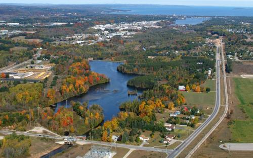
Look at this picture from Anderson Aerial Photography (visit the link for a huge version of the file).
What a place! My wife and I feel fortunate that we have been able to make a life here.

When you look at the area from the air the Boardman River is like a necklace draped over the landscape, giving the community a jewel to appreciate amidst the urban fabric.

I value that in-town Boardman Lake supports mink, beaver, red winged blackbirds, fox, bobcats, swans, loons, buffleheads, and a wide variety of sport fishing opportunities. Doesn't everyone get some pride out of telling out-of-town friends that we can hear loons - from downtown! Where else would this be possible?

What does the community value?

More car capacity or more capacity for the things people enjoy?

This winter I have seen my neighbors using the area where the Boardman Lake Avenue will go as an impromptu sledding hill; a safe space for teaching children how to XC ski; a play area for people and their dogs. Spring is coming and one of my favorite things on the first nice day is to grab a snack at Oryana followed by a walk over to Boardman Lake while experiencing the warm sunshine and the first red-winged blackbirds of the year.

This is what I value.

But now the City is calling this the West Boardman Lake Re-development project. I feel as though the City is appealing to our values by re-badging a road building project as parks and trails and we'll just throw a road in there for good measure. Thus I have become skeptical of the entire process. I have the sense that the City has already decided that a road is going to be built and all that matters now is how.

Though I am skeptical of a new road I am proud of my neighborhood. I am thankful to live in neighborhood where there is a small number of residents who care enough for the health and safety of their neighbors that they volunteer their time to make our neighborhood a better place. It is difficult for families with two careers, two kids, social engagements, and many other commitments to make it to the Neighborhood Association meetings so their dedication is appreciated. But Neighborhood Associations are not elected bodies, and never did I think they were decision making entities. Perhaps I missed it but I was never given a survey about my thoughts for a Boardman Lake Avenue. I never saw a neighborhood meeting where the pros and cons of a new road were discussed.

Because the dedicated tiny band of volunteers who are our Old Town Neighborhood Association were promised a road, they weren't promised a solution. The assumption was made that they were equivalents so the discussion never came up. But a road is not a solution.

Those of us who are in opposition to a road want the same thing as those who were promised a road - we all want a solution to traffic speeding through our neighborhood. It is well known in Engineering Departments that adding roads decreases overall traffic efficiency. They know about the Braess Paradox. Why didn't anyone tell the Old Town Neighborhood Association?

I am not opposed to building Boardman Lake Avenue to be divisive, I oppose it because I love my neighborhood and my neighbors and I want the best solution for all of us - all of us in Old Town and in Traverse City.

I want to find a traffic solution that signals to everyone that we develop our city for people, not cars.

I want to signal that we value financial responsibility, the well-being of our residents, and the health of our land and waters.

A flare is not only a signal to "come here", but it can also be a warning. These arguments are some of my road flares:

-History: Ask yourself this - if there's too much traffic going through your neighborhood what is the better solution, creating more capacity for more cars or making it easier for traffic to go around your neighborhood (e.g., on S Airport Rd)? History shows that a community has NEVER built a road like Boardman Lake Avenue and seen a decrease in traffic in the neighborhood.

-Financial: once the road is built the brownfield money spent on it is no longer available for any other projects. Where does the money come from when residents in Slab Town and Traverse Heights demand solutions too? How does Traverse City justify on-going maintenance costs of a new road while other streets are in need of repair and modernization, and with the City facing a $30+ million pension shortfall?

-Safety: A new traffic signal where Copy Central and Midtown are will lead to more congestion and more access points onto Eighth St. More access points create more opportunities for accidents.
Pedestrians who want to access Boardman Lake Trail will now have an additional road to cross, and a road that will be designed for a high volume of traffic. This will make it difficult for families who bike from Oryana to the Boardman Lake trail to do so without risking a conflict with a speeding vehicle.

-Health: There is known contamination between Cone Drive and Boardman Lake. Another unknown is how much more pollution will be encountered, therefore the remediation costs are unknown. And if this corridor is polluted who will build there? Plus, excavating through contaminated soil will threaten Boardman Lake. This road will increase salt and sediment runoff into Boardman Lake too.
And for Midtown residents, an extra traffic light here will lead to more waiting traffic polluting their air.

Traverse City has a chance here to reject the failed road building policy from the past and embrace a solution that makes the neighborhoods more livable.

Consider...

Would we build Eighth St the same way today? Would we bisect the City with a four lane street that pedestrians cannot cross?

Would we build Grandview Parkway the same way today? I think that if we were given the chance to do it over we would not cut ourselves off from the Bay.

Would we build Division St the same way today so that this busy street blocks pedestrian access to 500 acres of parkland?

So why would we try to build a new street that will block easy access to Boardman Lake, the library, and the Boardman Lake trail? Is that what we value?

I believe that we value solutions.

Traffic is like a giant bucket of water. Or a dam with an insatiable amount of water trying to get over it. You start with some trickles of water coming from a few holes. You make new holes and the water doesn't come out of those existing holes any more slowly, but you do get your feet wetter a whole lot quicker. Add more roads and all we'll end up with is a flood of traffic.

Add more capacity for people and we signal the reasons why we love living in Traverse City.

[this was Part 3 of what ended up being a three part series. Earlier posts are
Part 1: Traffic is a Gas
Part 2: You Can't Undo A Road]

Thursday, February 17, 2011

You Can't Undo A Road

Once a new road is built it will be there for a lifetime.

If it ends up being a mistake it becomes a very expensive mistake that the City has to subsidize. Roads, like parking, are an entitlement that once established cannot be rolled back. Best to avoid them in the first place.

Boardman Lake Avenue should be a last resort, not a first option.

If the concern is about traffic through the neighborhood then should the City make it easier for traffic to flow around the neighborhoods? Or should Traverse City add an extra path for traffic to use through the neighborhoods?

We all want to do something about traffic through our neighborhoods. I am not opposed to doing something to make the flow of traffic safer but I am opposed to a solution that will exacerbate the problems the neighborhoods face.

If someone can show me an example of where a new road like Boardman Lake Ave has helped then I would be happy to revise my opinion. But I have to base my opinion on the facts, and they are that roads such as this do not alleviate traffic congestion.

Here are the possible scenarios I see for Boardman Lake Avenue if it is built:

A: Boardman Lake Avenue works as advertised. Although there are no historical examples of this ever happening I'll indulge in a little fantasy. Cass between 14th and 8th is only used by local traffic and people wanting to go downtown take the long way of the new road. But if this is the case then we have a high speed (I know people say it will be 25 mph but 8th St is 25 mph too) high volume road sitting between Old Town and Boardman Lake and the library. People who used to walk to the library will now be intimidated by this road crossing and hence drive to the library.

Riverside Apartments becomes a local crash zone as pedestrians, bicyclists, and drivers try to negotiate multiple intersections on Eighth St.

Other residential areas such as W Front St demand action to the traffic that bakes up in front of their houses every day. Slab Town and Traverse Heights neighborhoods demand that the City do something about the cut-through traffic.

And they have a point. If the City is going to build a road for a few people in Old Town then every other neighborhood has a right to demand a similar solution to their traffic problem.

B: Boardman Lake Avenue is built and since most people are heading downtown, most people do not use it. The result is a multi-million dollar road to nowhere.

C: Boardman Lake Avenue is built as the West Boardman neighborhood. New houses and businesses are built. Not too much changes. The neighborhood just gets a little bigger, the City gets a little bigger tax base.

Problem with this scenario is I don't see how there's that much room for a new neighborhood, plus who would choose to live between Cone Drive and Boardman Lake when there is a know contaminated groundwater plume between the two?

D: Boardman Lake is built and Braess's Paradox takes over. Most people initially use the new road, but as the new road becomes busy drivers switch to Cass in an attempt to find a better route. Other drivers try the roads and finding neither overly congested start using Boardman Lake Ave and Cass more often. This leads to more traffic using 14th. More traffic on 8th. It becomes more difficult to drive anywhere in town because of the increased traffic volume that the new road has enabled. It becomes more difficult to walk from Old Town neighborhood to anywhere because high volume/speed roads have caged it in.

People complain that there's too much traffic. The City tries various traffic calming measures as they are the only remaining resource to deal with the situation.

History shows Scenario D is the predictable outcome.

Now consider a scenario where the entire traffic system is considered. Where road planning is done from a high level and for the good of the Community, not just one neighborhood.

The world is lazy. Capitalize on the laziness of people. Equilibrate and optimize traffic so that staying out of the neighborhoods becomes the lazy way to drive around and everyone can find happiness with the situation.

Think of the system.

I think about Pac Man - gobbling up dots around the outside edge of the screen - that is how I think about traffic going around the outside of the neighborhoods rather than through them.

Right now it is easier to drive through the neighborhoods. Why would we add another road to neighborhoods then? To make it even easier?

I think it is easier to edit than create so I am going to present my City wide traffic system plan as a starting point for others to edit and destroy:

-S. Airport Rd has to be a better east-west route with fewer stops and starts. There are so many stop lights there that it has become a hurry up and wait track.

The traffic light by Logan's Landing has been a disaster in my opinion. Auntie Pasta's has closed. The YMCA is going to move their main building. Rather than a traffic light here put in "Michigan left's" down by Goodwill and by Verizon. Recent research shows eliminating normal left hand turns can make a great improvement in traffic flow.

See:
Smithsonian: Life Without Left Turns

NCSU: Operational Effects of Signalized Superstreets in North Carolina.

-Are traffic lights needed at both Barlow and Park Dr? Remove access to Park Dr from S Airport Rd.

-Re-align Barlow - Woodmere - Railroad Ave with a roundabout at E 8th for an additional way into downtown.

-Division St needs to be a boulevard in the same kind of transformation that Woodmere Ave saw. Go from four lanes to two with "Michigan lefts" at key points.

-Redesign Grandview Parkway to force slower speeds with fewer stops. Right now it cuts off the city from the bay front in much the same way that I fear Boardman Lake Avenue will cut off the lake and library from the west side neighborhoods.

-Put in roundabouts at the peripheries of the neighborhoods. Use astrophysics. Let the mass of the roundabouts guide the traffic in a nice even flow. Division and 14th, Front St and Garfield Ave, Front St and Railroad Ave, Front St and Union, Front St and Division, as just a few examples.

Just as it was easier for Pac Man to go on the outside I imagine that if traffic had an unimpeded, though slow, flow at the edges of town then this would become the preferred route rather than through the neighborhoods.

And if traffic in the neighborhoods does not improve with a system approach then perhaps a Boardman Lake Avenue would be needed. But let's not have our first step be building a mistake we can't undo.

Likewise, if we drive from our neighborhood to the post office, The State, Horizon Books, or downtown restaurants and demand that the City build us a road to make our drives downtown easier then we're not helping matters. We need to undo those habits.

So I think I will add a Part 3 to this series - "road flares".